
The research in my group focuses on numerical modeling of the atmospheric boundary layer, which we use to improve predictions for wind energy, air pollution dispersion, and cloud dynamics, among other applications. The analytical and computational methods that we develop help to quantify climate change mitigation strategies, air quality effects, and cloud representation and feedbacks in regional climate models.
Current projects include studies of wind turbine interactions with boundary layer dynamics over steep terrain, wildfire smoke modeling, urban dispersion modeling, landfill methane emissions modeling, and improved numerical techniques for turbulence, representation of topography, and grid nesting, among others.
The Environmental Fluid Mechanics and Hydrology at Berkeley page describes further research in our group.
Read this 2023 article from The New Yorker which talks about our recent wildfire smoke model research, Why It’s So Hard to Forecast Wildfire Smoke
New turbulence closures for large-eddy simulation of clouds
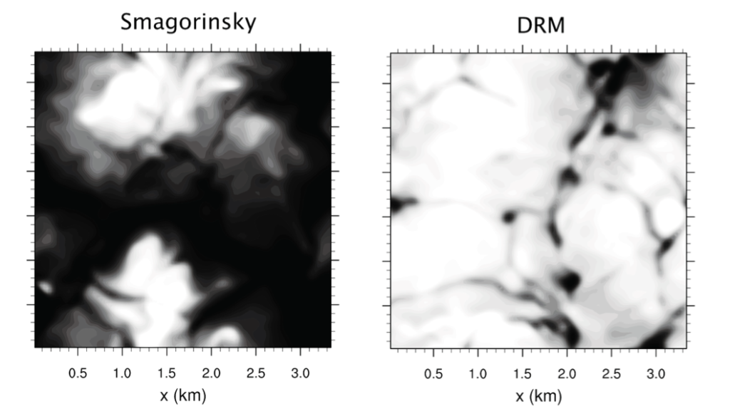
Clouds are important to the earth’s energy balance and a regulator of both climate and weather. In global climate models, cloud feedbacks are a leading source of uncertainty. We are performing large-eddy simulations of clouds using the dynamic reconstruction turbulence model (DRM). We have found that the DRM enables simulations of clouds with coarser resolutions and less computation time without much compromise in accuracy (Shi et al. 2018a). In addition, we uncovered additional shortcomings of traditional closure models, in particular related to the common assumption of a constant Prandtl number for scalar diffusion (Shi et al. 2018b). The new turbulence closure models will boost numerical models’ capability in simulating clouds, helping to advance understanding and predictions of the evolution of clouds and their effects on weather and climate.
Large-eddy simulation for wind energy applications
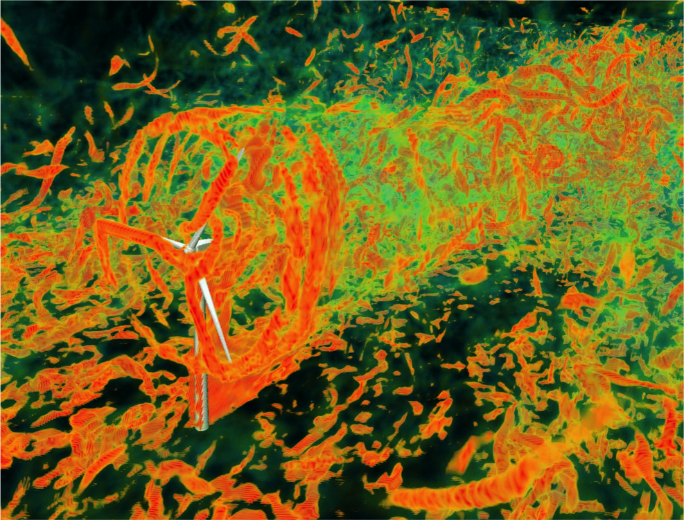
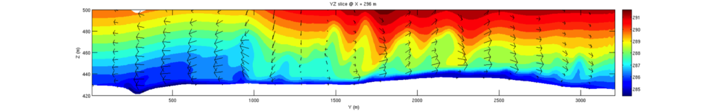
Wind turbine micrositing, for operational wind power forecasting and for turbine design, requires high-resolution simulations of atmospheric flow over complex terrain. We are developing large-eddy simulation (LES) for wind energy applications using the Weather Research and Forecasting (WRF) model. Grid nesting is used to refine the grid from mesoscale to LES scales which can adequately resolve terrain and turbulence in the atmospheric boundary layer. Grid nesting provides time-dependent lateral boundary conditions which incorporate changing weather conditions even in the smallest domain. In an initial grid nesting study, the goal was to understand what model configurations are needed to predict rapid wind changes called “ramping” events. These ramping events are notoriously difficult for wind farm operators to predict, giving uncertainties in energy yield which can be quite costly. We found that as long as the topography is adequately resolved, higher model resolution was not necessary, and afforded very little improvement in model accuracy. This can help save computational resources when forecasting for a wind farm. We have also implemented an actuator line model into WRF to represent the individual blades of the turbine as they rotate, providing a very detailed representation of the wake of the turbine. See Marjanovic et al. 2014, Marjanovic et al. 2017 for details.
The immersed boundary method – urban dispersion modeling
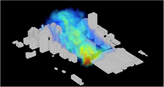
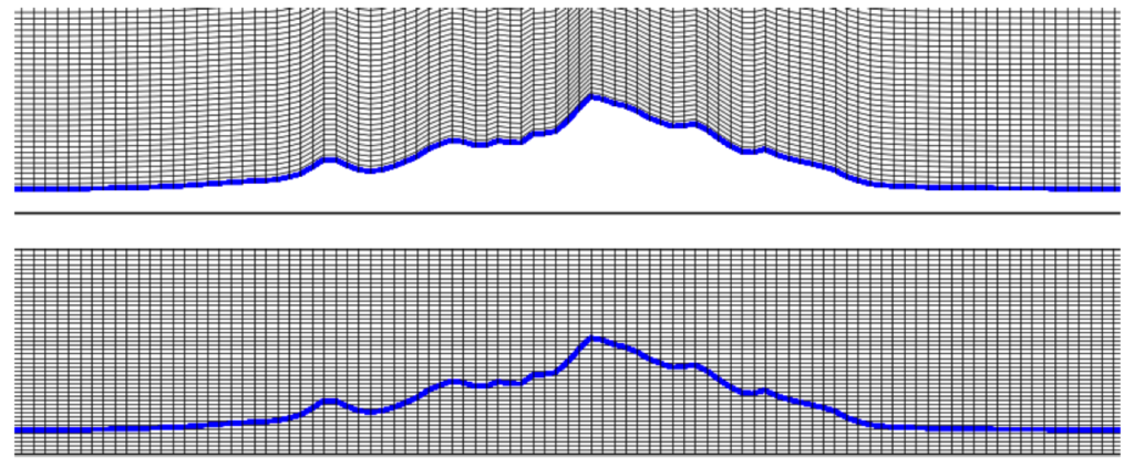
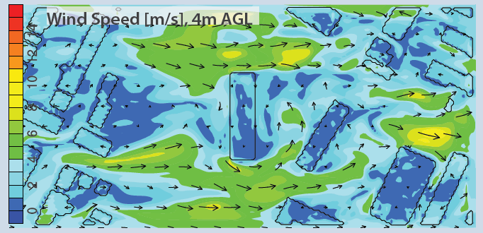
A major difficulty in atmospheric modeling is the representation of the steep “terrain” associated with very steep mountains or vertical building surfaces. The problem is two-fold: first, current weather prediction models (such as WRF) are limited to modeling slopes of a maximum around 30 degrees, and second, engineering flow models which could resolve urban geometries (buildings) do not include the influence of external meteorological forcing. In collaboration with Katie Lundquist at LLNL, we are developing and implementing an immersed boundary method (IBM) into the Weather and Research Forecasting (WRF) model, which will enable simulation over steep terrain surfaces within an atmospheric model. IBM improves the representation of steep terrain and allows representation of vertical surfaces (like buildings). WRF can now be used at the urban scale, but to make IBM robust and generally applicable, it needs to be compatible with nesting within WRF, use rough wall boundary conditions, and allow vertical grid refinement. Each of these features is in progress and will enable urban and complex terrain flow studies in a fully nested environment using the most sophisticated atmospheric physics modules available in WRF. See conference papers for details (Wiersema et al. 2014, Simon et al. 2012).
The MATERHORN project – flow over complex terrain
The Office of Naval Research funded MATERHORN project is a large collaborative effort led by the University Notre Dame with several partner institutions. A set of field campaigns at Dugway Proving Ground in Utah were completed in 2012-13 and an overview article describing the whole program is in the Bulletin of the AMS (Fernando et al. 2015). Our role is performing numerical simulations of stable slope flows on Granite Mountain. At the high resolutions needed to resolve these stable flows, the terrain steepness becomes such that traditional numerical models (such as the Weather and Research Forecasting (WRF) model, a community mesoscale model developed by NCAR) encounter numerical stability limits. Using the immersed boundary method (IBM) with WRF, we are first working to quantify the errors that result with increased terrain steepness. The next step is to use WRF-IBM to simulate real field conditions.
The Terra Incognita – or the Gray Zone – in atmospheric modeling
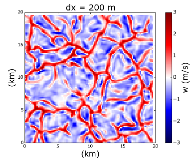
One of the current hot (and challenging) issues for turbulence simulations is the so-called gray zone or terra incognita. When the grid resolution is too coarse to resolve any turbulence, a full turbulence parameterization is used. When the grid resolution is fine enough, explicit turbulent flow structures can be simulated, as in LES. A problem occurs when the grid resolution is only fine enough to partially resolve the turbulent flow (in the atmosphere this happens for a grid spacing of around 1 km) – this is the region called the gray zone. Numerical weather prediction models are increasingly crossing into the gray zone, because of the trend for models to move to higher resolution. Simulations operating in the gray zone in the atmospheric boundary layer can produce ‘false’ convection, with unphysical convective cells. Simulations at higher resolution than previous forecasts can thus counter-intuitively produce more erroneous results. These findings are critical for models crossing into the gray zone (e.g. as being proposed by several national weather agencies across the globe) and will require new model configurations to help counteract the erroneous model behavior. See Zhou et al. 2014.
LES for urban air quality studies
New city regulations require that certain air quality standards be met in housing development areas, and our high resolution models can be used to choose appropriate building designs. In a collaboration with the Bay Area Air Quality Management District, we seek to predict air pollutant transport downwind of Interstate 280 in San Francisco at the site of a proposed low-income housing development. Traditional modeling tools use simplistic Gaussian plume models to predict downwind concentrations, but these models neglect the effect of buildings and topography. We are using the immersed boundary method (IBM) (described above) to explicitly resolve buildings and terrain, including proposed housing designs. It is possible that smart design of the housing development can help mitigate the effects of any air quality problems due to proximity to the freeway. We are currently working on idealized IBM simulations and building the code infrastructure to enable realistic boundary conditions (see Wiersema et al. 2014).
Atmospheric dispersion studies – methane emissions
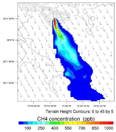
Scalar transport prediction is quite a challenge over complex terrain, where the winds are affected by terrain forcing and errors in wind direction can have significant impacts on scalar plume evolution. In a practical application with real implications, we are simulating methane plumes to monitor landfill methane emissions for greenhouse gas control. Current measurement techniques used by the EPA are limited and rely on the wind blowing in the right direction to get downwind measurements with the tracer dilution method. We are using a set of nested atmospheric simulations to capture scalar plume transport from the landfill, given high resolution land surface and topography data. These simulations aim to identify best practices for tracer gas release and downwind sensor placement. This will help the EPA develop standards for landfill emissions, which are currently self-reported with large inherent error bars. This work is in collaboration with Paul Imhoff and Madjid Delkash at the University of Delaware. See Taylor et al. 2016, 2018.
Explicit filtering and turbulence modeling for LES
The technique of large-eddy simulation (LES) resolves the largest turbulent motions in the atmosphere, but a turbulence closure model is needed to represent smaller scale motions. Under nighttime conditions, stable stratification occurs, such that turbulence is damped and often intermittent, making it hard for large-eddy simulation to faithfully represent fluid motions. Our explicit filtering and reconstruction turbulence model has the ability to simulate very strongly stable conditions in the atmosphere, where previous modeling attempts have failed (simulations could not sustain the surface cooling). The modeling results also confirm the presence of an “upside down” boundary layer structure that has been observed in field measurements of the stable boundary layer. This work first investigated idealized flows and then two real cases over complex terrain, one in the Great Plains (CASES-99 field data) and one in the Sierras (using T-REX field data) (see Zhou and Chow 2011, 2012, 2013, 2014).
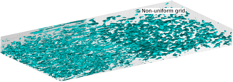
Adaptive mesh refinement and LES – explicit filtering and turbulence modeling
Adaptive mesh refinement (AMR) is used to refine the grid near solid boundaries – for example, it is commonly used in urban dispersion simulations to refine the flow around buildings. LES and AMR cannot easily be used together because of underlying limitations in each approach, which lead to turbulent flow features in LES becoming distorted by grid refinement interfaces. We have performed idealized simulations of homogeneous turbulence with a grid refinement boundary to represent a simple AMR scenario and investigate the effect of the refinement interface on the development of turbulent structures in the flow. We found that use of our explicit filtering and reconstruction turbulence modeling framework helps to reduce numerical errors at the grid interface. See Goodfriend et al. 2013, 2015, 2016. This work is done in collaboration with Elias Balaras and Marcos Vanella at George Washington University.
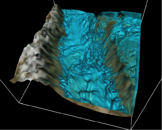
The Terrain-induced Rotor Experiment – Owens Valley
Owens Valley, California is famous for many reasons, from battles over its water resources (the Los Angeles Aqueduct starts here), to the “Sierra Wave” and the daring flights of the Sierra Wave Project in the 1950s. Owens Valley was the site of the Terrain-induced Rotor Experiment (T-REX) field campaign in Spring 2006, which focused on understanding lee waves and atmospheric rotors generated by strong winds over the Sierra-Nevada mountains. We performed high resolution simulations of nocturnal quiescent conditions in Owens Valley which explained peculiar physical phenomena which were observed in the field. For example, our simulations shed light on an unusual nighttime warming event (in contrast to the typically expected nighttime cooling). This warming event was found to be generated by a shear-induced mixing event which brought warm air from aloft down to the ground. The simulations also discovered a mechanism for intermittent turbulence observed during the stably-stratified nighttime period. A cold-air intrusion was observed on the eastern slope of the valley which generated a series of Kelvin-Helmholtz billows which propagated across the valley. The agreement with field data in this study was impressive because the intermittent nature of the turbulence was well captured in our model, which is typically difficult to do. See Zhou and Chow 2013, Schmidli et al. 2009, and Grubisic et al. 2008.